Sturgeon Lake Restoration Project

Sturgeon Lake is reconnected to the Columbia River!
After over a decade of partnership building, planning, fundraising, and engineering, and just over four months of construction, in November 2018, the Dairy Creek channel reopened to tidal flow between the Columbia River and Sturgeon Lake on Sauvie Island.
The successful completion of the Sturgeon Lake Restoration Project hinged in part on closing a set of conservation easements with the landowners surrounding the project. In August, the District closed on the last of four easements and also successfully completed a required irrigation reconfiguration for one of the landowners. These accomplishments – in which landowners were compensated based on the appraised fair market value of the easements – give the District permanent access to these lands for monitoring and maintaining the project, including management of the native plant resources as well as monitoring and control of unwanted invasive plants.
The District also closed on the necessary road easements from one landowner and assigned these easements to Multnomah County so that the county can inspect and maintain the Reeder Road bridge per county requirements. Similarly, the Oregon Department of Fish and Wildlife granted to Multnomah County a road easement.
Ongoing work includes finalizing the Intergovernmental Agreement for long-term monitoring and maintenance of the project with the Oregon Department of Fish and Wildlife and Multnomah County. We are currently working with the Oregon Wildlife Foundation on developing an interpretative kiosk for the project, finalizing recognition for a significant private donor for the project, as well as launching fundraising for the stewardship fund for long-term monitoring, maintenance, and resource management for the project. Lastly, we are working on securing from the Oregon Department of State Lands permanent access for channel maintenance below the tidally influenced high water mark of Dairy Creek.
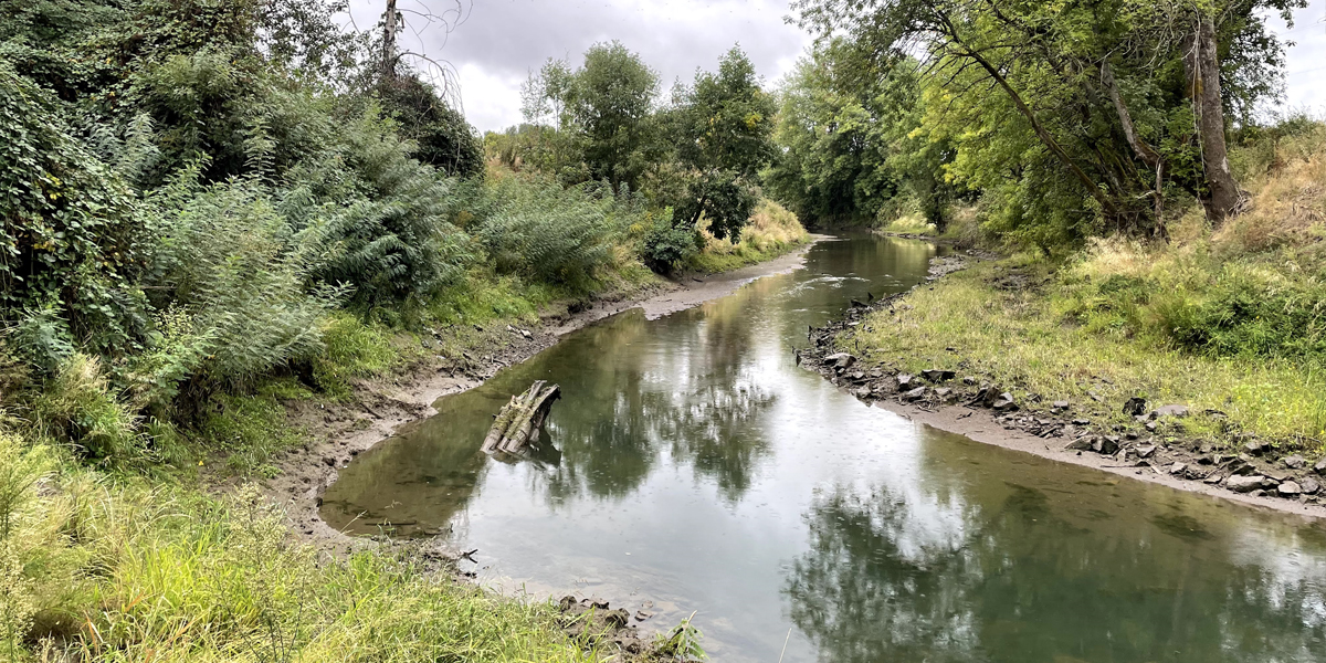
In November 2018, the construction crew from Elting Northwest, Inc, overseen by Columbia River Estuary Study Taskforce (CREST), completed work on Dairy Creek, removing all debris and dirt that had been blocking the channel. Crews removed the temporary bypass bridge on Reeder Road, and the last of the soil and sandbags blocking the flow of water in the channel. The new bridge is fully operational and open to all vehicle, bicycle, and pedestrian traffic. Here’s an aerial view of the completed creek, captured by CREST.
Crews planted the creek banks with native trees and shrubs, to replace the thickets of non-native blackberry and false indigo bush that were removed at the beginning of construction. We will continue to monitor the lake for invasive species that might travel up the creek from the river.
In summer of 2017, Conservation District staff conducted a survey of the Sturgeon Lake shoreline looking for potential invasive plants. While we found little of significance, this established important baseline information needed before the Sturgeon Lake Restoration Project could reestablish a tidal link between Sturgeon Lake and the Columbia River through Dairy Creek. Now that the creek is reopened, new weed seeds will be able to float into the lake, so it will be important to keep a vigilant eye out for new invaders to help keep the lake pristine and maximize its value to fish and wildlife.
Celebrating 75 Years of Conservation:
Rural Program Spotlight on Sturgeon Lake Restoration Project
Project background
West Multnomah Soil & Water Conservation District (WMSWCD) worked on the restoration of Sturgeon Lake since the District was formed in 1944. By that time, the Bonneville and Grand Coulee Dams were constructed on the Columbia River, denying upriver access to migratory salmon. The U.S. Army Corps of Engineers (USACE) built an 18-mile levee in 1941 to prevent annual flooding of more than 11,000 acres of prime agricultural land on Sauvie Island. That project severely restricted natural flows to Sturgeon Lake leading to increased sedimentationSedimentation Fine soil particles that are washed into streams collect at the bottom and make water cloudy and greatly reduced aquatic habitat function. While a federally-funded project re-opened the channel from the Columbia River via Dairy Creek in 1989, subsequent floods blocked the creek’s mouth and reversed efforts to restore flow.
In 1982, an Oregon State University study concluded that a connection between the Columbia River and Sturgeon Lake was necessary to reverse sedimentation. Dairy Creek at the south end of the lake was identified as the best option for that connection. In 1985, WMSWCD created a partnership with Oregon Department of Fish and Wildlife and the Oregon Department of Environmental Quality to explore ways to re-establish the Dairy Creek connection, and subsequently completed a creek channel redirection in 1989. However, the historic floods of 1996-97 sent sand and woody debris to the mouth of Dairy Creek, plugging the channel. Shortly thereafter, many Columbia River salmonid species were listed for federal Endangered Species Act protection.
In 2007, WMSWCD convened a work group to take another look at options to re-open Dairy Creek or find other alternatives. The USACE completed a feasibility study of the project area, which totals 10,580 acres and includes Sturgeon Lake and the surrounding land on Sauvie Island. WMSWCD signed on as the “local sponsor” of the project. The study recommended replacing the failing culverts over Dairy Creek at Reeder Road, removing the sand plug from the mouth of Dairy Creek, and re-configuring the Dairy Creek channel.
The total project cost $6.5 million, of which WMSWCD raised $1.5 million under a matching fund agreement. The Conservation District secured $1 million from the Bonneville Power Administration (BPA), $300,000 from Multnomah County to replace two plugged culverts, and $100,000 from Metro. In addition, the Oregon Wildlife Heritage Foundation designed and operated a fundraising campaign for the District and exceeded its own goal of raising $365,000 from its members and supporters.
Due to BPA funding a more significant portion of the project costs, management of the project was transferred from the US Army Corps of Engineers to BPA. In turn, BPA partnered with the West Multnomah Soil & Water Conservation District and CREST to oversee the final design and construction of the project.
Project Library
See photos from the construction, view FAQs, updates and historical information about this project.
Significance of Sturgeon Lake
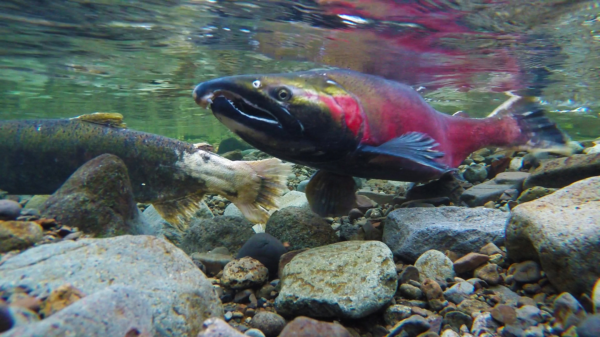
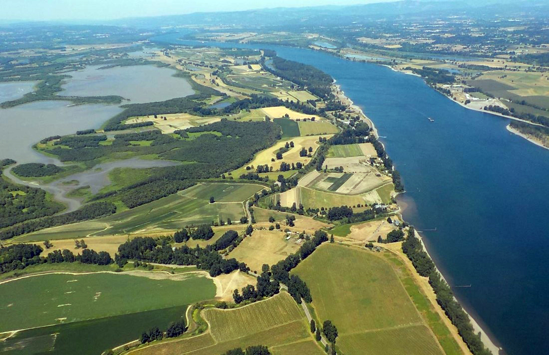
Sturgeon Lake (3,200 acres), owned and managed as wildlife refuge by Oregon Department of Fish and Wildlife (ODFW), borders and is connected to Multnomah Channel via the Gilbert River and is connected to Columbia River by Dairy Creek. It is one of the premier natural and biologically significant aquatic and wildlife habitats in the state. Sturgeon Lake is an important link in the Pacific Flyway for waterfowl and a wide variety of bird species, offering winter habitat to 200,000 geese alone. In addition, juvenile salmon will leave the main river and seek refuge from high flows within the lake and sloughs. They use this time to increase in size and heartiness which in turn increases their likelihood of survival when they reach the ocean. Sturgeon Lake is identified in the Oregon Conservation Strategy as a “conservation opportunity area” and restoring flushing flows to the lake for salmon habitat restoration is specifically named as a state strategy.
The lake is the largest tidally-influenced freshwater lake in the United States. In addition to the benefits to wildlife, some 800,000 people recreate on Sauvie Island every year, spending time in the Wildlife Area, hunting, fishing, hiking, using the beaches and visiting farms to buy fresh produce.