by Eleanor Greene, outreach and communications coordinator
The Sturgeon Lake and Dairy Creek restoration project on Sauvie Island is one of our largest, longest, and proudest accomplishments as a District. As part of the project, which was officially completed in 2018, it was agreed that some of the funding from supporters would go to creating an interpretive sign that explained the project and thanked the funders. Of course, life happens, funding changes, and it’s challenging sometimes, to find a place to put up a large sign!
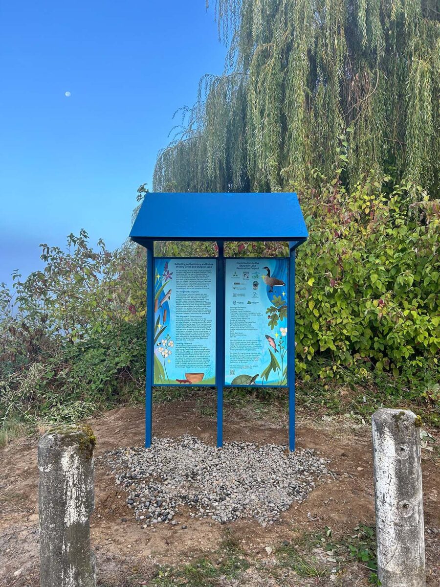
But things came together this year, when stakeholders agreed upon a site and the District began to work with contractors to tell the story of this project. One of our key partners was Mark Nebeker at Oregon Department of Fish & Wildlife, who is the manager of the Sauvie Island Wildlife Area. Besides allowing the sign to be on ODF&W land, and providing feedback on sign text, he helped us by making a survey of all the interpretive signs on Sauvie Island. While there were many signs that gave information about the nature on the island, there weren’t any to do with the Native people who inhabited the area before colonists.
We were excited when David Lewis, PhD, agreed to work with us to write this narrative. He is a member of the Confederated Tribes of Grand Ronde, a descendant of the Takelma, Chinook, Molalla, and Santiam Kalapuya peoples of western Oregon. Dr. Lewis has done extensive anthropological historical research and writing on the Western Oregon Tribes and has been active in our District giving talks on his book Tribal Histories of the Willamette Valley (2023), and on ecological history of the area.
Dr. Lewis recommended reaching out to Chanti Manon-Ferguson for the artwork for the interpretive sign. Chanti is an Indigenous artist he had met while she was a student in one of his classes at Oregon State University. She has contributed art and design to projects at the Fort Vancouver National Historic Site in Washington, the Native American Youth and Family Center, and the Portland Art Museum, among many others. For our interpretive sign, she incorporated many of the native plants and animals Dr. Lewis wrote about, as well as cultural artifacts of the area.
In addition to the narrative, and a thank you to the funders of the project, we also included a memorial tribute to Brian Lightcap, a longtime board member of West Multnomah SWCD, who advocated for the Sturgeon Lake/Dairy Creek project for decades and gave the dedication when the restoration portion of the project was completed. In this image, he is standing in almost the exact place where the sign now stands.
We encourage folks to go visit the interpretive sign in person and watch the plants and flowers rustle in the breeze, and see the clear waters of Dairy Creek flowing in or out.
If you don’t get a chance to visit the sign, here is the text and imagery:

Reflecting on the History and Future of Dairy Creek and Sturgeon Lake
You are standing at Dairy Creek, which connects to Sturgeon Lake, named for sturgeon (stachən: Chinuk wawa), large fish that live on the lake’s bottom. Chinookan Tribes of the middle Columbia River lived on and stewarded the resources of this land since time immemorial. The tribes lived in at least five villages: Cathlahcommahtup, Clanninata, Clannarminamon, Clannaqueh, and Multnomah. Other Chinookan villages, of related bands the Quathlapottle, Clackstar, Cathlacumup, and Nemalquinner, dotted the shoreline of the river.
The Original Ecosystem
The Chinookans harvested, cooked, ate, and traded wapato (wapthu), a native wetland plant with nutritious bulbs. Because of the plentiful wapato (11 subspecies inhabit the island), Lewis and Clark called the island Wappatoo Island. Wapato marshlands attracted more than 200,000 waterfowl annually to feed during their migrations. Multnomah bands fished for sturgeon in the same wetlands in the winters while Dairy Creek also hosted a run of wild salmon. The plentiful seasonal resources allowed the Chinook tribes to have large permanent villages in this vicinity for generations.
The Impact of Colonization
Chief Kiesno was the last major chief of the Multnomah peoples. White settlers brought malaria and other diseases to the area around 1830, which led to the deaths of at least 75% of the Multnomah peoples. Kiesno gathered the remaining Chinookan peoples near the island under his leadership and lived here until his passing in 1848. In 1855, Federal Indian Agents removed the Multnomah people to a temporary reservation near St. Helens, Oregon. In 1856, the Multnomah, renamed the Ne-pe-chuck, were removed with the neighboring Clatskanie people to the Grand Ronde Indian Reservation, about 90 miles southwest.
Looking Forward
The Sturgeon Lake Restoration Project reconnected the Columbia River to Sturgeon Lake through Dairy Creek and was completed in 2018 with the support of federal, state, local, and tribal partners along with local property owners. By reducing sedimentationSedimentation Fine soil particles that are washed into streams collect at the bottom and make water cloudy within the lake and creek, the project opened up thousands of acres for habitat for salmonid and sturgeon species. Monitoring data shows that each year, increasing sturgeon and salmon access the lake using the creek. The lake is a waterfowl sanctuary with a thriving wapato-rich Native ecosystem, managed by the Oregon Department of Fish and Wildlife.
Contributors to the Sturgeon Lake Restoration Project
West Multnomah Soil and Water Conservation District, Oregon Department of Fish & Wildlife, Columbia River Estuary Taskforce, Oregon Wildlife Foundation, The Confederated Tribes of Grand Ronde, Bonneville Power Administration, Oregon Watershedwatershed an area of land that channels rainfall, snowmelt, and runoff into a common body of water, such as a nearby lake or river. Multiple streams can be part of the same watershed area, such as the Tryon Creek Watershed which is fed by Oak Creek, Park Creek, Falling Creek, and others. Enhancement Board, Ducks Unlimited, Metro, Multnomah County, Wessinger Foundation, Hilltop Foundation, The Reser Family Foundation The Oregon Community Foundation funds (Mary E. Horstkotte Field of Interest Subfund, Phil and Jo Chase Fund, Martha Staley Marks Fund), Gordon & Dodie King, Ann & Bill Swindells Charitable Trust, Papé Family Foundation Trust, R.H. Parker/United Foundation, Oregon Duck Hunters Association, Oregon Waterfowl Festival Association, ESCO, Bud & Kathi Smith, Scott & Linda Andrews, Dave Sill
West Multnomah Soil & Water Conservation District board member Brian Lightcap (1944-2024) dedicated nearly 40 years to making this restoration project a reality. We gratefully remember his commitment to bringing fish back to Sturgeon Lake.
We thank Dr. David Lewis, member of the Grand Ronde Tribe and Assistant Professor at Oregon State University, for the narrative, and Chanti Mañon-Ferguson, Indigenous artist, for the illustration of this sign.
For more information about this project, visit wmswcd.org/sturgeon-lake.