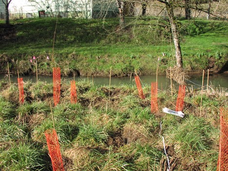
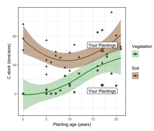
In 2023, scientists from The Nature Conservancy (TNC) and University of Oregon (U of O) began a study to measure the carbon sequestration of restored riparian areas in western Oregon. The study included two sites on private land where West Multnomah SWCD staff had planned and implemented restoration projects. In the preliminary results released in October, the study showed that soil and plantings in our two projects, in the Rock Creek and Abbey Creek watershedswatershed an area of land that channels rainfall, snowmelt, and runoff into a common body of water, such as a nearby lake or river. Multiple streams can be part of the same watershed area, such as the Tryon Creek Watershed which is fed by Oak Creek, Park Creek, Falling Creek, and others., have sequestered approximately 33 tons of carbon per acre (combined) since they were planted in 2007. That’s equivalent to taking 25 gas-powered cars off the road for a year, or the same amount of carbon sequestered by 110 acres of U.S. forests per year. You can see in the charts below how that compares to other sites included in the study.
Ecologists and conservationists have understood for some time many of the advantages of intact riparianRiparian areas The land alongside a stream, creek, river, or floodplain forests and vegetation. Benefits include keeping our streams and streamside areas cool and shady; improving water and air quality; limiting erosion; providing corridorsCorridors Wildlife corridor: a stretch of habitat that connects natural areas separated by human land use and habitat for wildlife; and offering noise- buffering, aesthetic and many other benefits to humans. A subject that is less understood is how much carbon riparian ecosystems store and that relationship to climate change mitigation. This lack of detailed knowledge is what drove the desire for this study.
How the Study Worked and the Results
To facilitate this study, West Multnomah SWCD staff reviewed the study criteria, proposed sites, coordinated with TNC, got landowner permission, and helped with field work. Study sites needed to be at least 2.5 acres (equivalent to at least 1 hectare) and the plantings needed to be at least five years old. TNC and Clean Water Services researchers measured water infiltrationInfiltration Water absorbs into the ground instead of running over the surface and collected soil samples up to an 18-inch depth and data on woody materials. The woody materials measurements included the diameter and height of live and standing dead trees; the height, width and canopy cover of living shrubs; and the size and condition of “down wood” on the riparian forest floor, as well as overall canopy closure and the nature of the ground cover. The data were collected in randomly selected plots, sub-plots and transects.
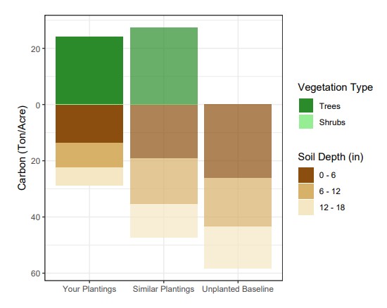
U of O researchers subsequently analyzed the collected soils in the laboratory—to determine the amount of carbon stored below ground. In collaboration with TNC, they used the data on the species and sizes of the trees and shrubs observed to calculate their biomass and the amount of carbon stored inside their wood. The researchers are also evaluating the overall effectiveness of riparian restoration and best practices, which they will include in the final report made to the Oregon Watershedwatershed an area of land that channels rainfall, snowmelt, and runoff into a common body of water, such as a nearby lake or river. Multiple streams can be part of the same watershed area, such as the Tryon Creek Watershed which is fed by Oak Creek, Park Creek, Falling Creek, and others. Enhancement Board (OWEB).
The principal researchers for the study are Dr. Rose Graves, Conservation and Climate Scientist for TNC, and Dr. Regina O’Kelley and Dr. Lucas Silva of U of O.
Applying the Results
July 2025 update: The study has now been published in the journal of Environmental Research Letters.
The researchers plan to publish their final results and conclusions, based on all 43 of the study sites in western Oregon, in spring 2025. The results will help restoration practitioners better estimate the climate benefits of their riparian reforestation efforts and could inform the development of a carbon calculator for riparian plantings.
Perhaps most important, we will collectively understand more precisely how planting and restoration projects can help meet Oregon’s climate mitigation goals. In 2021, Oregon’s Climate Action Commission (formerly the Oregon Global Warming Commission) recommended the state increase net carbon sequestration from natural and working lands by 5 MMTCO2E (i.e., five million metric tonnes carbon dioxide equivalent) per year by 2030 and nearly double that amount by 2050. OWEB’s recent Climate Resolution also identifies climate mitigation and adaptation as priorities.
Given that there have been nearly 3,000 riparian restoration projects on 22,000 acres in Oregon between 1995 and 2020, we are reassured that the habitat enhancement we do along streams and other waterways provides a great public benefit.
